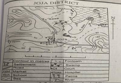
Concept:The highest point on a topographical map is found from the highest enclosed contour or the highest spot height near the summit.
Explanation:On the Joja district map, compare all the marked heights and contour values.
The peak area is represented by the highest contour or spot height shown.
Reading the summit carefully, the highest elevation is estimated to be about
395m.
Values such as
325m,
375m, and
390m are lower positions on the relief.
Therefore, the top of the mapped area lies closest to
395 metres above sea level.
Answer:The highest point of the mapped area is approximately
395 metres.
Correct option:
D. 395 m.