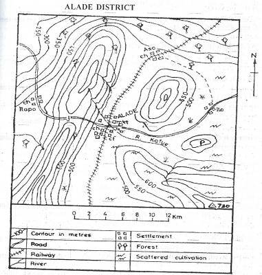
Concept:The actual ground distance on a map is found by measuring the route length and comparing it with the scale provided.
Explanation:Use a piece of thread or the straight edge of a paper strip to measure the railway line.
Starting from one end, carefully follow the full curved path of the railway track and mark the finish point.
This method captures all the bends in the railway line.
Now place the marked thread or paper strip along the map scale.
Read the distance where the second mark touches the scale.
This gives the approximate ground distance represented by the railway line.
When converted with the map scale, the measured length is about
40 km.
Out of the given choices, this value is closest to 40 km.
Answer:40 km (Option C)