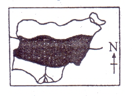
Concept:The vegetation zones of Nigeria are arranged in broad belts from the southern coast to the northern border, and the map letter D lies within the Sudan savanna zone.
Explanation:From south to north, the main vegetation belts are mangrove swamp, tropical rainforest, guinea savanna, Sudan savanna, and Sahel savanna.
The area marked D is located north of the guinea savanna belt.
In Nigeria, the Sudan savanna occupies the zone immediately north of the guinea savanna.
This region receives less rainfall than the forest and guinea zones, so it is covered mainly by short grasses, scattered thorny trees, and drought-resistant plants.
Typical crops grown there include cattle, groundnut, guinea corn, and millet.
The Sahel savanna lies farther north, where water shortage is even more severe and vegetation is very sparse.
Therefore, the belt shown as D is not high forest, guinea savanna, or Sahel savanna.
Answer:D. Sudan savanna